Wildfire Data Reveals Russian Military Exercises
Turns out NASA's FIRMS system doesn't just detect wildfires - it also detects artillery, explosions, airstrikes, and other military activities
Highlights from today’s post:
Public data revealing decidedly non-public things
Wildfire data showing what the Russian army was doing over the past year, where they were doing it, and when
Some, uh, unique uses of QGIS, Google Earth, and Wikimapia
In light of the Russian military’s recent buildup near Ukraine, I decided to focus this week’s piece on what Russian forces have been up to over the past year. In doing so, I went back to a well I’ve drawn from before: wildfire data1.
It shouldn’t be a surprise to anyone that when modern militaries train, things catch fire.
Between the explosions, gunfire, hot exhaust, exposed wiring, cigarettes, and dozens of other warm things carted along by armies, there are thousands - millions! - of chances for things to catch fire during training. This is even more true on the Russian military's training ranges, ensconced as they are in dense forests and dried-out plains.
Fortunately for our purposes, NASA maintains a system called FIRMS that uses satellite data to detect “thermal anomalies” (fires) around the world. I used that system, visualization tools, and imagery to reveal when and where the Russian military was training, including both announced and unannounced training exercises. If you want to try this method at home, you can give it a shot for really any military, as long as you know generally where they are training or operating.
Hot Stuff
Downloading the thermal anomaly data from FIRMS was super easy. I requested data for all fires detected in Russia in 2021 and they emailed it to me in an hour or two. I loaded the shapefiles they sent me into QGIS and good lord that’s a lot of fires.
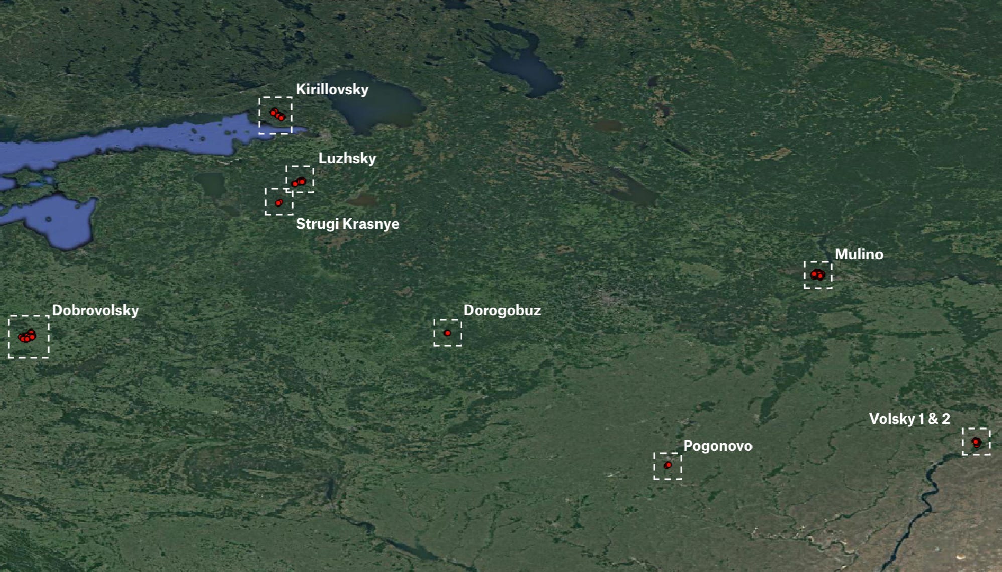
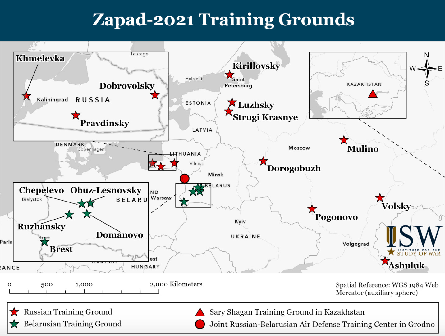
To cut down on the amount of data to examine, I filtered these fires by only those detected within the boundaries of known and recently used Russian training ranges. First, I selected the training ranges mentioned in a map composed by George Barros at the Institute for the Study of War. These ranges were used in a series of Russian exercises held in September called Zapad-2021.
Next, I searched Wikimapia data in Google Earth for each of the Russian training grounds mentioned in the map. I traced the outlines for each one2, saved them as polygons, opened them in QGIS, and layered the FIRMS fire data over them.

But there’s a problem - notice how there are lots of dots (fires) detected outside the training ranges? Those would only confuse me and mess up my analysis, so, using QGIS, I clipped the fires data to the training ranges, meaning that only fires detected within the bounds of the training ranges would be visible.

Of course, it’s unrealistic to expect FIRMS to detect all fires at all ranges in 2021. Keep in mind much of Russia is covered in snow for several months per year, making fires less likely in winter. Overcast conditions also obscure the ground from satellites, so any fires that break out on cloudy days go undetected by FIRMS. Nonetheless, the 552 fires detected inside the ranges in 2021 provide a great deal of insight into what the Russian military was doing during clear days in the spring, summer, and early fall of last year.
Through the Fire and Flames
To test out this technique, let’s examine a simple example from Russia’s Pogonovo training range in April. A few fires were detected by FIRMS at the northern end of the range on April 13.
I searched the Russian military’s website for mentions of Pogonovo around that time and found a press release published on April 17 confirming that troops recently conducted artillery training at the range.
Satellite imagery corroborates this training as well. One of the FIRMS fire detections corresponds to a patch of torched land surrounding what appears to be firing positions for artillery or armored vehicles. It’s conceivable that during the exercise, smoke and fire from the muzzle blasts at the firing positions ignited the small fire detected by FIRMS on April 13.
FIRMS surfaces more interesting examples as well. For instance, I noticed two massive clusters of fires at the Mulino training ground in mid-July. These dates correspond roughly to the dates of exercises held to prepare for the massive Zapad exercises in September. Once again, the Russian military’s website confirms several exercises involving tanks and artillery were held at the training ground in mid-July.
Zooming in, these fires tip us off to military activity and the development of military infrastructure at the training areas. Two access roads, several vehicle parking or storage areas, and dozens of entrenched positions were built by Russian forces near areas that later turned up burned.
But not everything detected by FIRMS is already public. For instance, Volsky, one of Russia’s most sensitive military locations, experienced a series of fires last year, none of which were connected to exercises announced by the army. On at least four instances between April and October, fires broke out near a series of chemical weapons facilities known as Shikhany-23, which hosts a unit of Russia’s Nuclear, Biological and Chemical Protection Troops.
To be absolutely clear, satellite imagery shows that land at the facility is regularly torched - perhaps the fires ignite naturally, perhaps they’re lit to keep grass short, or perhaps they start for some other benign reason (as could technically be the case for all of the fires mentioned in this piece).
But of the numerous fires there, one in particular caught my eye.
It was detected by FIRMS on August 19 and took place squarely within what Wikimapia calls a “training center” for the Nuclear, Biological and Chemical Protection unit based at Shikhany-2. High resolution imagery from the following month confirms a considerable amount of land was burned within the boundaries of the training center. As far as I could find, no snazzy press releases were published on the Russian military’s website about any exercises at the range in August.
Given the secrecy of the site (and the corresponding dearth of ground-level images), it’s difficult to determine what that part of the range is used for, however, it could be fire suppression training or training for some of the NBC troops’ numerous flamethrower-equipped units or simply a natural grassfire that got out of hand. Whatever the cause, Volsky is a good example of how FIRMS can bring otherwise extremely privileged information to light.
Hundreds of miles to the west, the current conflict between Russia and Ukraine remains limited to sections of eastern Ukraine, although Russia has been sending tens of thousands of troops to the areas bordering Ukraine over the past few months. With the region blanketed in snow (and likely to remain that way until spring), most training fires in the area won’t appear on FIRMS until the ground thaws.
However, as soon as the snow melts, you can be sure FIRMS will detect the flames and smoke associated with Russian training or, God forbid, an invasion of Ukraine.
Finally, it’s worth mentioning that this method is country-agnostic. With a little open source trickery involving FIRMS, Google Earth, QGIS, and elbow grease, anyone can examine any army’s training areas — American, Chinese, Russian, whoever — worldwide to determine exactly when and where they’re preparing for the next big fight.
If you know how to get kmls from Wikimapia in a programmatic way/without tracing polygons, please, for my own sanity, get in touch.
One expert even alleged this location is where the novichok nerve agent used to poison former spy Sergei Skripal was produced, although there is some disagreement on that point.


