


The Destruction of Kyauktan Village
Examining the claims of the Arakan Army

Since the beginning of March, Myanmar’s military, the Tatmadaw, has systematically targeted Kyauktan, an agricultural village beside the Mayu River, with artillery, naval gunfire, helicopters, and small arms.
The majority of the news about the clashes comes from the Arakan Army, a Rakhine ethnic group that has been fighting the Tatmadaw since 2009. The Arakan Army advocates for self-determination for the Rakhine people and a degree of independence from the central Burmese government.
Recently, fighting has centered around Paletwa, an area northeast of Kyauktan. The Tatmadaw claims that fighting moved toward Kyauktan as the military tried to dislodge Arakan Army fighters in the village and in the hills to the east.
News reporting and information from the separatist Arakan Army confirms that during the first week in March, at least three separate shelling incidents destroyed homes and farmland in the village. Fortunately, no civilians were killed or injured in the fighting, although hundreds have been displaced.
March 1
The Tatmadaw offensive began on March 1 with, according to the Arakan Army, a daylong artillery barrage, followed by naval gunfire targeting the Kyauktan area. Reporting from BNI Online confirms these allegations and adds that two helicopters contributed to the destruction.
The Arakan Army, in their statement about the start of the Tatmadaw offensive, also said that the military cut off internet access for the area. Unfortunately, that means that there is very little independently-verifiable media about these clashes.
March 2
On March 2, combat reached a fever pitch. The Arakan Army published another report saying that the events of the previous day had transpired yet again. The Myanmar Times added that “two Tatmadaw vessels fired several artillery shells in Kyauk Tan, damaging 10 houses”. Helicopters, mortars, and gunfire raked the town.
On the same day, Radio Free Asia filed a video report from the clashes, which provided the first media of the fighting in the area.
The clip between 0:53 and 0:57 in particular is verifiable to farmland southeast of Kyauktan village. Kyauktan, a small agricultural hamlet, doesn’t show up on many maps. However, Relief Web’s detailed humanitarian map of Rathedaung township places it on a small fork of the Mayu River:

The clip of the plume of smoke was filmed here, at the intersection of the red lines:


The video corroborates other details of the Arakan Army’s reports. The helicopter that the militants said fired at the village is likely the same one pictured in the RFA report. When the aircraft banks at 0:46, the aircraft’s slender tail and two stubby wings level with the rotor are visible. The Tatmadaw operates Mi-24 Hind helicopters that match that aircraft’s profile.


The RFA video also shows the fin sections of what appear to be two mortar rounds, confirming that, whether fired by the Tatmadaw or the Arakan Army, artillery did strike the village.
March 4
The clashes quieted down on March 3 but flared up once again on March 4. The Arakan Army posted a long summary of clashes in Kyauktan on March 4 as well as a YouTube video that allegedly shows a home in the village destroyed by artillery fire.
At first glance, the metal-roofed structure in the background looks distinctive. Unfortunately, that style of building is extremely common in Kyauktan. Many houses in the village have similar green-blue eaves and peaked roofs surrounded by heavy vegetation and tall trees.
A few possible candidates for that location are shown below:


Low resolution, dense jungle, and infrequent imagery unfortunately conspire to make confirmation of any of these sites extremely difficult.
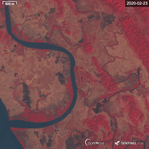
Indeed, the most damning evidence of the Tatmadaw’s offensive against Kyauktan can be seen by comparing before-and-after satellite images of the farmland southeast of the village. Sentinel-2 satellite images taken on February 28 (before the offensive) and March 4 (after the bulk of the offensive) and treated with a false color filter highlight the devastation of the town.

The black splotch, denoting burned farmland, southeast of the village seen in the March 4 image shows just how severe the fires that swept the area were, likely during the intense March 2 fighting.
Worse, Kyauktan is not unique. Before-and-after images show similar black marks throughout the area surrounding Kyauktan:
While, fortunately, no civilians were harmed during this latest round of fighting, combatants, whether the Arakan Army or the Tatmadaw, must take steps to ensure that innocent people, homes, and property, are safeguarded.