Iron Dome Misfires, Nearly Strikes University
On January 30, the Israeli military’s Iron Dome air defense system badly misfired after rockets were fired from Gaza into southern Israel. Instead of downing the rockets, an Iron Dome missile nearly slammed into a university near the town of Sderot. Geolocated social media videos show the path of the missile as it looped in the sky before exploding on the ground, causing a fire.
The first video, filmed from a residential neighborhood in the east of Sderot, shows the missile at its apex. During a flash in the video (which is when a correctly-fired Iron Dome missile intercepted a rocket), red roofs, a blue tarp, a tan building with a billboard, and a long, grey-ish platform are visible:
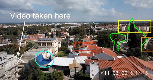
Unfortunately, Sderot does not have high-resolution satellite imagery available, so locating these videos and the missile strike had to be done with the tools that were available, namely, pre-geolocated online photos, Google Street View, and blurry satellite images. After some searching online, I found a daytime photo taken by a tourist that appears to show the same area. Thanks to the better resolution and light, additional clues, such as the pointy tree, palm tree, and apartment block to the right are all visible.
Adding all those visual clues together produces this spot:
For final confirmation, here is the Google Street View of the building outlined in orange compared with the photo taken by the tourist:
Though some details changed in the six years between the two photos (e.g. the upper level windows), the majority of the features (e.g. the two a/c units, grated second floor window, roof water tank, roof solar panels, and front door) are an exact match.
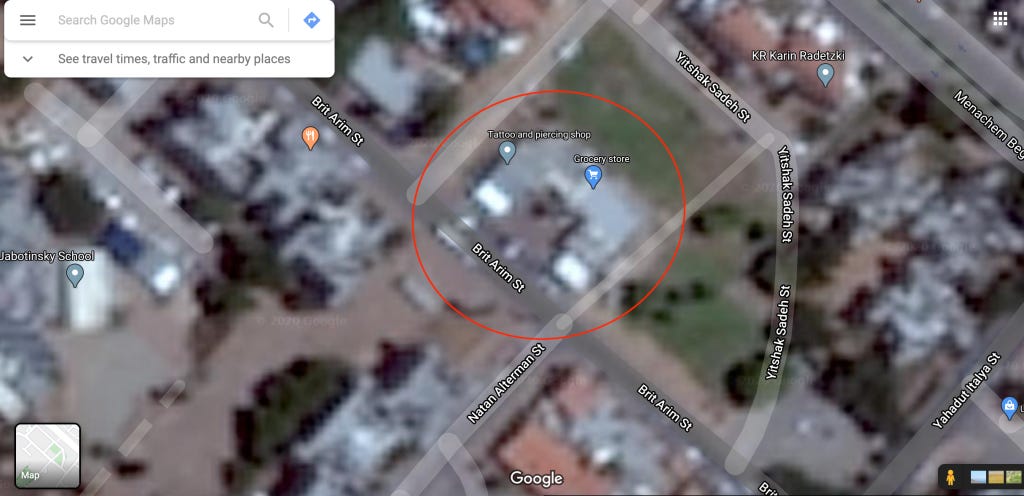
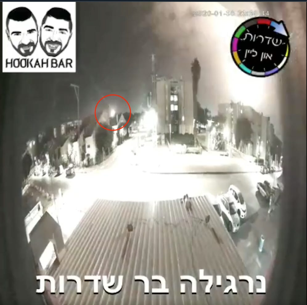
The second video, taken by a hookah bar’s CCTV camera, is easier to locate. Google returns several results for hookah bars in Sderot and, from there, it’s a simple matter of comparing Google Street View at each bar’s location with the CCTV footage. The second video was taken from the horseshoe shaped building here:
In both videos, the missile is seen rising vertically in the night sky before looping in the air and slamming back to earth. The initial, vertical rise is important because it confirms that the malfunctioning object is an Israeli Iron Dome missile, not a rocket fired from Gaza. Publicly available diagrams show Iron Dome missiles are launched at a 90 degree angle with the ground and maneuver in the air to intercept the enemy projectile. Conversely, rockets are launched at a much more acute angle with the ground and form an arc-shaped path in the sky:

With the location of each video showing the missile’s malfunction established and the Iron Dome confirmed as the system that launched the misfired projectile, we have to find where the missile actually landed! To do so, I measured the distance between where each video was filmed and the missile’s last visible position in each video.
For the first video, the missile disappeared behind this stand of trees:
I mapped the line between where the video was taken and the stand of trees on Google Earth:
And then extended it to show an approximate path along which the missile may have fallen:
In the second video, the missile disappeared behind the roof of this house:
The line between where the video was filmed and where the missile disappeared:
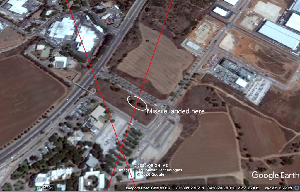
And the extension of that line to where it intersects with the line established in the first video:
Lo and behold, the area where the two lines intersect, near Sapir College, is exactly where Israeli news media said a “rocket” fired from Gaza fell:
מתיחות בדרום | בהמשך לצבע אדום שנשמע בשדרות ושער הנגב: ככל הנראה רקטה אחת נפלה סמוך למכללת ספיר ושתי רקטות נוספות יורטו ע"י מערכת כיפת ברזל @bokeralmog
— חדשות 13 (@newsisrael13) January 30, 2020
From Google Translate: “One rocket apparently fell near Sapir College and two other rockets were intercepted by the Iron Dome system”
However, footage of where the “rocket” fell confirms that what exploded near Sapir College was not a rocket at all, but was instead one of the Israeli Iron Dome missiles.
A video published by Walla News shows Israeli police vehicles cordoning off a road lined with trees and a grassy hillside. A closer image of the same hillside shows a tree and some land engulfed in flames.
שלוש רקטות נורו לעבר שדרות ושער הנגב; שתיים יורטו ע”י כיפת ברזל – וואלה! חדשות https://t.co/KBh1KtD10t pic.twitter.com/Tarm01u7z1
— מוקד החדשות של ישראל (@mokednewsil) January 30, 2020
Confirming that location as where the Iron Dome missile fell was relatively easy with Google Street View:
Roughly where the missile landed, per the Walla News video. It likely burned one of the trees, not visible in this image, near the hillside marked in yellow. Note the debris marked in white from where the electricity towers in the below image used to be.
The scene of the missile strike on Google Street View. The trees that the Iron Dome missile burned are far more clear in this image.
Finally, the scene of the missile strike on Google Earth’s overhead imagery.
The malfunctioning Iron Dome missile landed extremely close to the location predicted by the two social media videos (the intersecting red lines), confirming that the projectile that nearly struck Sapir College was, in fact, an Iron Dome missile and not a rocket fired from Gaza.
While the malfunction itself is concerning, the location of the malfunction is even more worrying. The trees that the missile struck were less than 80 meters from the closest building, a rehabilitation center, and roughly 250 meters away from the grounds of Sapir College, the largest public university in Israel and the home of nearly 8,000 students. Had the missile struck either of those, the physical, economic, and reputational damage of the Iron Dome’s misfire could have been catastrophic.


