Despite my general loathing toward conflict, I have to admit there’s something fascinating about submarines and the planes that hunt these underwater beasts. I think it may be rooted in the David and Goliath nature of sub-hunting. It’s compelling (and not a little quixotic) to think of the small group of Davids flying in funny-looking planes trying to collect enough pebbles for their slingshots - a blip on a sensor here, a clip of engine noise there - to slay the watery Goliath carrying enough weaponry to end human civilization multiple times over.
In that spirit, I set off to learn more about the anti-submarine warfare aircraft of the US Navy. After a few false starts (namely because I wanted to use purely open-source information and there’s not much public info about sub hunting methods out there), I decided to examine the Boeing P-8 Poseidons of Air Test and Evaluation Squadron One, also known as VX-1 or AIRTEVRON ONE.
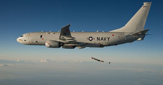
A P-8A Poseidon dropping what appears to be a sonobuoy. Credit: Greg L. Davis
The squadron does a few different things, including testing equipment and training personnel on several types of aircraft. But it does one thing better and more often than other Navy flight units: find new ways to hunt submarines. And lest you have any doubt that sub-hunting is their primary mission, take a look at their, ahem, subtle unit patch:
Credit: Air Test and Evaluation Squadron One Facebook page
The other benefit of VX-1 is that they have a frequently updated Facebook page. Using the pictures posted to that page, I compiled a list of the (at least) four P-8s operated by the unit, which have Mode-S hex codes ae2230, ae4eb1, ae5f37, and ae222d, with registration numbers 167955, 167956, 169542, and 167952, respectively.
I plugged each hex into a snippet of code I wrote to pull the flight times of each airframe over the last month from the plane-tracking site OpenSky Network. For instance, here are the four times (measured in Unix timestamps) at which aircraft ae222d was first seen by OpenSky Network:
Note that each “firstSeen” time doesn’t necessarily correspond to a new flight. OpenSky Network issues a new “firstSeen” time after each instance in which an aircraft that had not been broadcasting a position resumes position reports.
I took those timestamps and plugged them into a slightly different code to get the flight paths (coordinates, altitude, time of day, heading, etc.) for each plane over the past month and save them as a .csv file:
In all, I collected about 6,800 lines of data making up at least 13 separate flights and comprising over 61,400 individual data points. Of the four P-8s belonging to VX-1, ae2230 was seen most often, with about 4,700 lines of data and nine separate flights, while ae5f37 wasn’t seen at all over the past month.
I uploaded my .csvs to Kepler, an open-source mapping platform, and admired my handiwork - a map of every publicly available position for the US Navy’s P-8s in sub-hunting unit VX-1 from March 5 to April 5, 2020:
Already, a few interesting patterns stand out - the orbit over the Texas/Oklahoma/Arkansas border for instance, or the back-and-forth laps over the Maine coastline. If we zoom in over the unit’s base in Maryland, at Naval Air Station Patuxent River, even more detailed patterns emerge. Individual approaches, holding patterns, training areas, and takeoff and landing routes become apparent (remember, VX-1 does a lot of routine flights as well as submarine hunting):
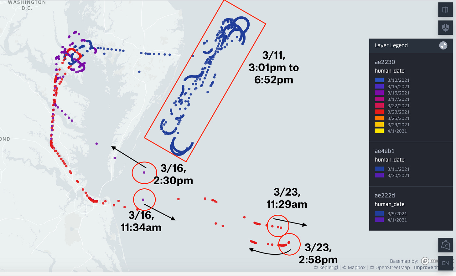
But what really caught my eye are two flights by ae2230 and one flight by ae4eb1 over the Atlantic Ocean. First, on March 11, ae4eb1 was tracked flying in a racetrack pattern off the coasts of Virginia, Maryland, and Delaware for nearly four hours at between 12,000 feet and 30,000 feet. For the flights on March 16 and March 23, ae2230 was tracked flying out toward the ocean at 9,000 feet, stopping position reports for about three hours, reappearing near the coast at around 21,000 feet, and returning to base.
Naturally, I wanted to find out more. In a stroke (well, three strokes) of truly astonishing luck, Sentinel satellites captured images of the areas under all three flight paths.
First, on March 11, at the southern tip of ae4eb1’s flight pattern, Sentinel-2 spotted the aircraft carrier USS Gerald Ford operating near three smaller vessels. At the northern end, two military aircraft flying in a staggered formation were seen zooming southwest along the coast. The image was taken at 1pm local time, i.e. two hours before ae4eb1 showed up.
Skies off the coast of Virginia were overcast on March 16, so visual imagery isn’t much help for that date. However, a Sentinel-1 synthetic aperture radar image (which thumbs its nose at the fair weather requirements of visual imagery) captured a veritable armada sailing north of ae2230’s flight path that day.
Again, the USS Gerald Ford appeared, this time accompanied by a Ticonderoga-class cruiser and a few smaller vessels (possibly Coast Guard cutters or patrol boats). Further south, a second possible Ticonderoga-class cruiser was seen right under ae2230’s inferred flight path. The SAR image was taken at 5:50pm - a few hours after ae2230 returned to base.
Besides the ships seen or possibly seen in satellite imagery, ship spotters in Norfolk, VA also snapped pictures of the submarine USS New Mexico leaving its base for the open ocean that morning.


Finally (and most interesting), on March 23, a Sentinel-2 image captured what may be a full blown anti-submarine exercise involving ae2230 and a host of other interesting ships and aircraft off the Virginia coast.
The image below was taken at 10:50am local time, which was right before ae2230 arrived. Based on timestamped position records, ae2230 had just taken off when the image was taken, meaning that the P-8 was barely out of the frame to the northwest.
Given the time of the image, the duration of ae2230’s flight, and the positions that we do know of for the aircraft, it’s likely that the cruiser, the littoral combat ship, and the amphibious transport dock were all under the sub-hunter’s flight path on March 23.
Finding and tracking these planes and ships is all well and good, but what were the P-8s of VX-1 actually doing off the coast of Virginia during these three flights?
I found an appendix to a Navy environmental impact statement about a section of the Pacific Northwest that says P-8s, like the planes above, are explicitly involved in eight different types of training activities: bombing exercises, submarine-tracking exercises, surface-vessel intelligence collection exercises, and five types sonobuoy tests to find, stalk, and communicate with submarines. They may be involved in others, but the impact statement only mentions P-8s by name in those eight activities.
If that pattern also holds true for the Virginia coast, we can make some guesses about what ae2230 and ae4eb1 were doing on those three flights. According to the document, bombing exercises only last an hour while surface-vessel intelligence collection and sonobuoy tests “typically last 6 hours”. The three flights examined here are all around three hours long, making them too long for bombing exercises but too short for surface intelligence or sonobuoys.
That leaves one final option - submarine tracking.
Note for all you open-source fanatics out there: this document is a goldmine for information on US Navy air, surface, and subsurface training.
Sub hunting training is a good fit for these three flights but admittedly not perfect. The Navy document says submarine tracking exercises can last between two and eight hours, which is right in the sweet spot of the flight lengths I observed. They also say the exercise can involve a single maritime patrol aircraft, which also holds true with the flights above. Finally, they specify that a “submarine may provide service as the target”, which, as shown by USS New Mexico heading out to sea in the second example, is true in at least one of the three flights - and possibly more.
But the document also says maritime patrol aircraft drop their sub-tracking sensors into the ocean at altitudes below 3,000 feet, even though they do acknowledge that “sonobuoys may be released at higher altitudes”. We don’t know the altitudes for the majority of ae2230’s two flights, while ae4eb1’s altitude fluctuated between 12,000 feet and 30,000 feet. Of course, ae2230 could have dipped below 3,000 feet after it stopped reporting positions - we just don’t know for sure. The Navy document also doesn’t mention anything about involving surface vessels in the P-8’s submarine-tracking exercises (even though surface vessels are clearly involved in other anti-submarine training).
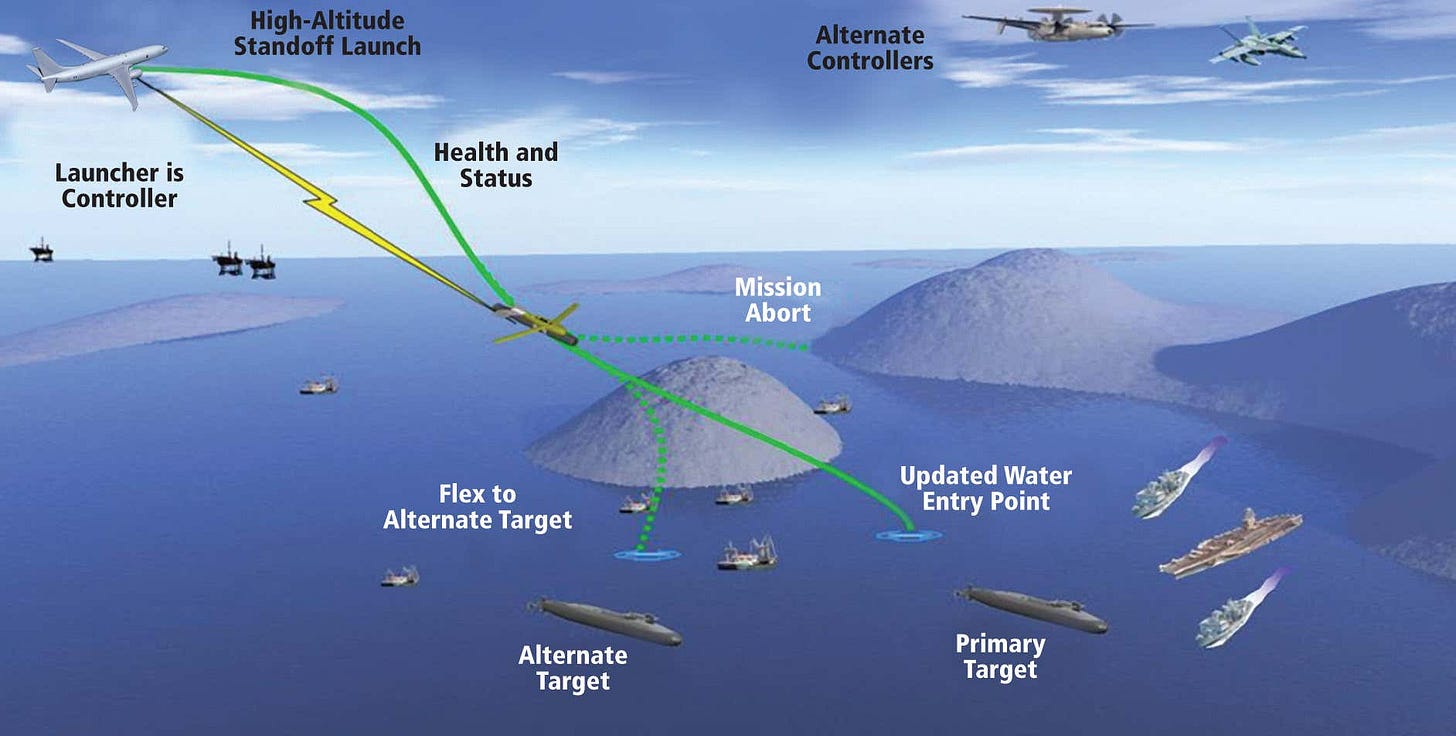
A final possibility not contained in the Navy report is that the P-8s were testing a few emerging technologies that both hunt submarines and require high altitudes, such as the awfully succinct High Altitude Anti-Submarine Warfare Weapon Capability. Articles about these weapons confirm that they’re fired at 30,000 feet and that the aircraft don’t have to deviate from a flight pattern to fire them, which lines up well with the flight paths of the VX-1 P-8s.
The articles also say that the weapons can be fired in conjunction with a variety of other ships and aircraft, like the cruisers and aircraft carriers in the three examples I examined. In fact, one of the graphics in The Drive article linked above looks a bit like the maps I plotted of the ships, submarines, other aircraft, and P-8s.
Credit: The Drive
So what were ae2230 and ae4eb1 actually doing? I’m not totally sure! But submarine-tracking seems like a safe bet. We have to keep in mind that VX-1’s primary mission is to develop new ways to hunt submarines, so they very well could have tossed out the assumptions in the Navy document while testing out new sub-hunting doctrines. Many of the vessels the P-8s were seen operating near, such as the cruisers or the littoral combat ship, are also able to conduct anti-submarine warfare, so it’s entirely possible that the ships and planes were mixing and matching their tools and capabilities.
Whatever the case may be, three of the four P-8’s in Air Test and Evaluation Squadron One were pretty darn active in March, with at least two of them likely conducting some submarine hunting off the coast of Virginia, probably with the cooperation of a few surface vessels such as Ticonderoga-class cruisers, a Gerald Ford-class aircraft carrier, and others.
Despite the lack of information available about the Navy’s perpetual search for underwater Goliaths, it turns out that we can learn quite a bit about these airborne Davids using only open-source methods.
As always, if you liked, hated, or have feedback about this piece, drop a comment or shoot me a message on Twitter!


