


“For all targets: Moscow time is 14:00”
Unencrypted Russian military radio transmissions reveal an artillery strike in Mariupol

Highlights from today’s post:
How ham radio is a new front in today’s information warfare
Some very interesting details of radio intercepts from Russian forces
A brief foray into Soviet maps
High resolution satellite imagery of eastern Ukraine
But first! Need to convert geo coordinates into useful location information?

This week's edition is sponsored by OpenCage who operate a highly available, simple to use, worldwide, geocoding API based on open data. Try the API now on the OpenCage demo page.
I’ve also been listening to the MapScaping podcast recently and figured that if you like this blog, you may like the podcast too. Give it a listen here.
Over a month after the Russian invasion of Ukraine, billions of people around the world know of Vladimir Putin’s aggressive and bloodthirsty move against his country’s neighbor. What may have gone unnoticed, however, is the incredibly shoddy state of Russian equipment. In particular, their communication systems.
It’s no surprise that strong communications are necessary to fighting and winning a war. Calling in reinforcements, evacuating casualties, maneuvering units, and virtually anything else soldiers need to do relies heavily on secure, fast, and interconnected communications systems.
However, the corrupt and kleptocratic Russian military has robbed their soldiers of even the most basic radios, forcing junior officers to procure off-the-shelf civilian models for use in combat.


Problem is, unencrypted traffic on Russian military frequencies can be picked up and heard by regular people operating what’s known as SDRs — software defined radios. These allow users from all over the world to tune into essentially a website and listen to radio frequencies of all types, from the BBC to music to pirate radio stations to, as we’ll see today, Russian artillery units.
"In five minutes, be ready to work on all fronts" "Understood"
@xateond is one of the folks who has been listening to and translating Russian military frequencies since the start of the war1. On March 3, they noticed, transcribed, and posted to Twitter a conversation between two Russian soldiers, with call signs Volk and Consul.
Based on the exchange, Consul appears to be a high-ish ranking officer, with the authority to order artillery strikes across a wide front. Volk, on the other hand, is either a battery commander or an artillery spotter responsible for delegating and correcting fire.
Their conversation essentially consists of two parts. The first part — late at night on March 3 — is real time, with Consul ordering batteries to fire at unidentified targets and Volk reporting the results in real time. The second part is Consul’s meticulous orders for an enormous artillery barrage the next day. He tells all batteries to be ready to fire at “14:00 Moscow time” on March 4 with what appears to be the coordinates for at least 27 different targets2.

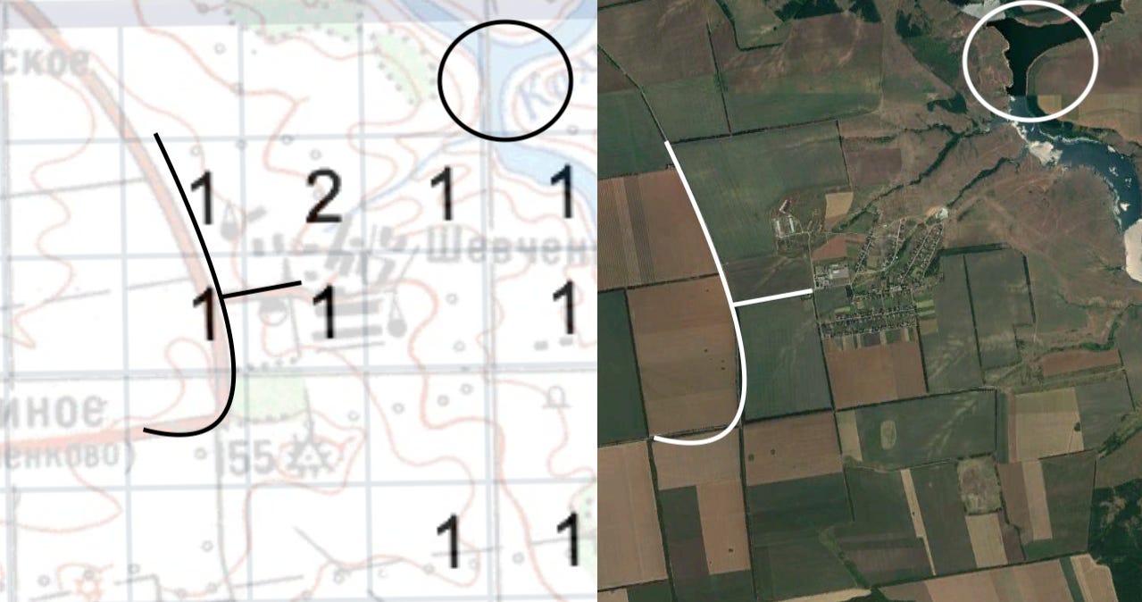
My curiosity piqued, I transcribed the 27 coordinate sets recorded by @xateond into a grid, with the coordinates rounded to the nearest whole number and placed in their correct positions on X and Y axes. So, for instance, the numbers in the tweet above would get a mark in the box at the intersection of 82 (on the X axis) and 37 (on the Y axis).
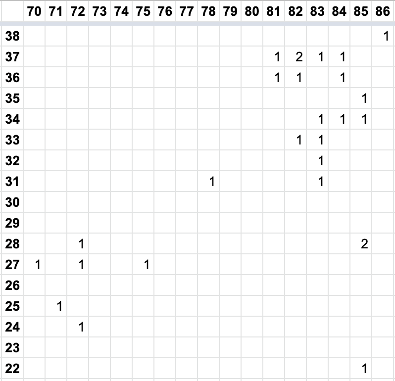
The coordinates (if that’s indeed what they are) have a loosely diagonal orientation, from the southwest to the northeast. To confirm my theory that these 27 numerical combinations were coordinates, I turned to an unusual source: old Soviet maps.
I noticed these Soviet maps had similar numbers running along their X and Y axes. I spoke with John Davies of sovietmaps.com, who confirmed that the axis numbers on these maps are “Gauss-Kruger values”, which show how far a point on a map is from the equator and a reference meridian.
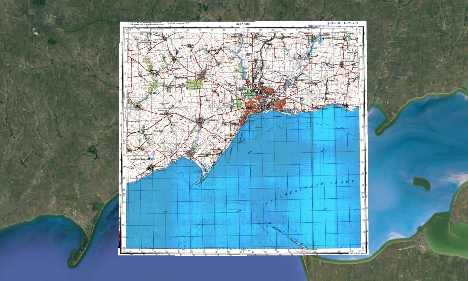
One map of Mariupol, then called Zhdanov, caught my eye because the axis numbers in the grid above and the numbers in a section of the map seemed to match up particularly well.

Moreover, Mariupol’s northwest front has been heavily contested by Russian and Ukrainian forces since the beginning of the war. A [pro-Russia] analyst even made a map of the frontlines, showing that the area in the map above was in a no-mans-land between Russian and Ukrainian forces on March 3 and 4, the dates of the alleged artillery strikes.
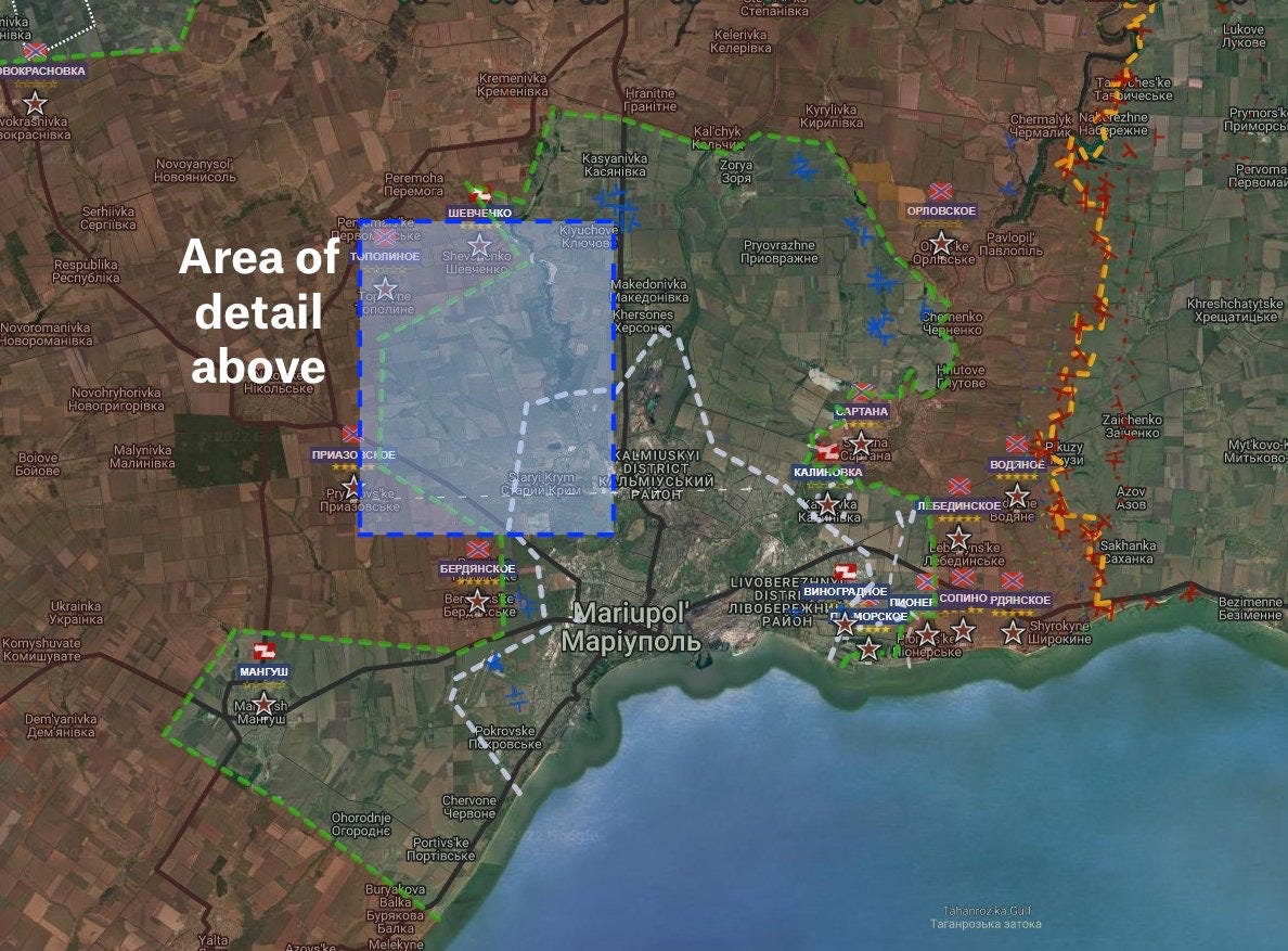
Could it be that Volk and Consul were preparing an artillery strike to pound the northwest outskirts of the city? Let’s examine further.
A Matter of Mapping
First of all, we have to establish that the coordinates Volk and Consul were discussing are still in use and that the coordinates above are not just some relic of Soviet cartography. To prove that, I drew on some information released by the Ukrainian Defense Ministry earlier in the war about captured Russian maps.
This Russian map, captured on March 2, shows Russian plans for an amphibious landing in southern Ukraine near the small town of Strohanivka.

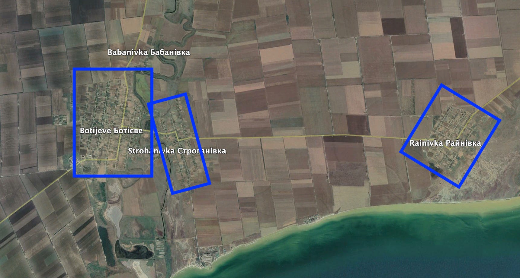
Meanwhile, here’s an insert of a Soviet map from 19803 of the location of the amphibious landing near Strohanivka seen on the 2022 map.

On the far right of the Soviet map, take note of the Gauss-Kruger values marked in light green, along the north-south axis from 70 to 80. The same location in the invasion map is marked with the same exact numbers. While the maps themselves look drastically different, the most significant component — the maps’ coordinate system — is unchanged from the 1980 map to the 2022 map. This pattern held true for other Soviet and captured Russian maps I examined as well.
Since the coordinate system from Soviet times is still in use during the invasion of Ukraine, we can use the coordinates on Soviet maps to approximate the location of the coordinates transmitted by Volk and Consul. Then we can use high-resolution satellite imagery to further pinpoint the location of each strike.
I first placed the Soviet map of Mariupol/Zhdanov in its spatially correct, georeferenced position on Google Earth.
I then overlaid my Google Sheets grid of the target coordinates transmitted by Volk and Consul onto the correct position in the Soviet map.

If my theory holds, evidence of artillery strikes under each target number should be visible on satellite imagery. Let’s examine Volk and Consul’s target 133, for example:
On the grid, it corresponds to a patch of land sandwiched between a reservoir to the north, the town of Staryi Krim to the south, and an industrial district to the east.
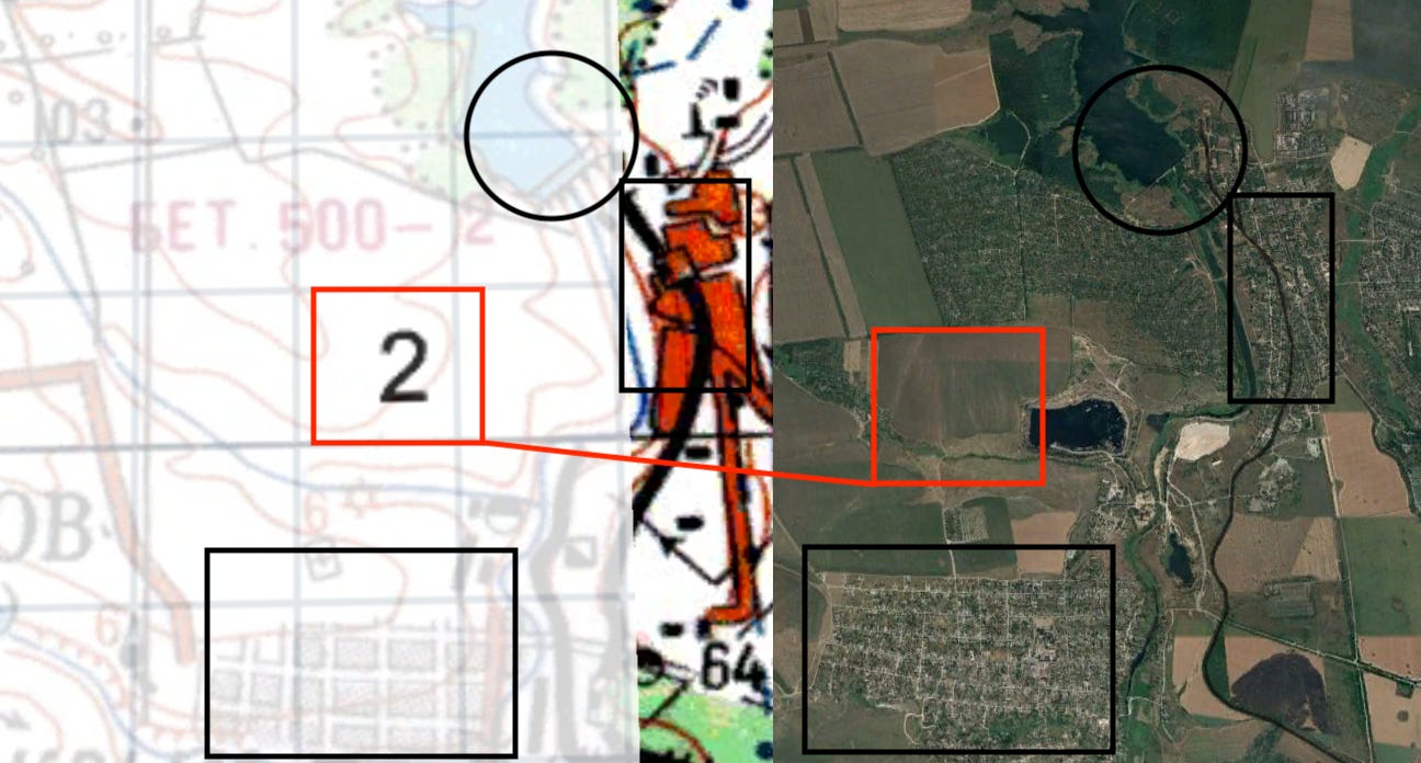
On satellite imagery, a black splotch of burned land is located precisely where the coordinates indicated it would be.
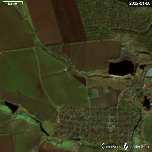
The pattern shows up again and again. This triangular plot targeted by Volk and Consul appears to have been part of a farm before the war.

Now it’s a pockmarked ruin and a large fire, whether from artillery or something else, has clearly burned some land north of the highway it sits along:
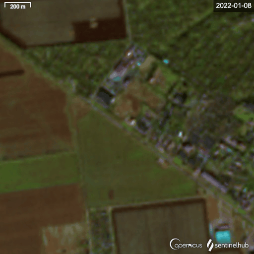
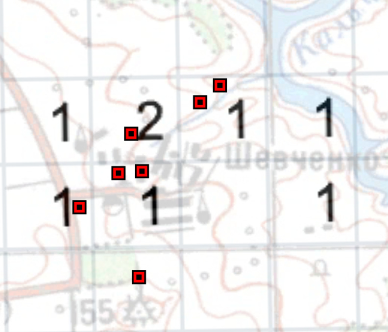
Or take a look at the village of Shevchenko. Volk and Consul prepared coordinates for at least eight targets in and near the village (with several more targets to the south).
West of the village, there are at least two patches of blackened land along roads. The northern strip also contains what appears to be the remains of two vehicles — perhaps destroyed in a Russian artillery strike.
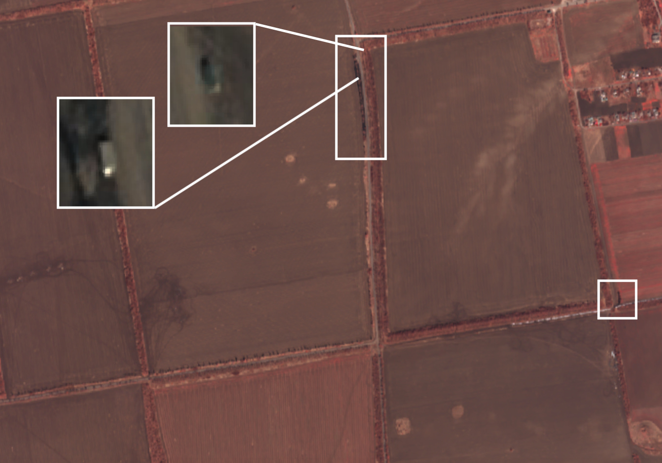
The story is the same north of the village. While Shevchenko itself seems to have thankfully been spared, some ruined buildings outside the hamlet show at least three scorch marks, possibly from Volk and Consul’s artillery.

While we can’t singlehandedly prove that Volk and Consul’s artillery caused these strikes, the similarities between the coordinates they called in and the craters or burned land that appeared near Shevchenko are too similar to ignore.
As long as this piece may have been, I’ll try to summarize it here concisely.
Radio hobbyists overheard Volk and Consul — two Russian artillery officers — using unencrypted (for some reason) tactical communications to plan an artillery strike over the northwest front of Mariupol on March 4. Soviet maps from the 1980s (which use the same coordinate system as captured modern Russian maps) and high resolution satellite imagery from 2022 show exactly where some of these strikes may have landed.
If you have additional context or information to add, don’t hesitate to drop a comment, message me on Twitter, or shoot me an email at lineofactualcontrol@protonmail.com.
At this point, massive thanks are in order to xateond, without whom no part of this investigation would have been possible.
Note that while only 27 different targets were mentioned explicitly, the targets were numbered between 110 and 145, implying that there could be more - many more - targets in Volk and Consul’s area.
This map is actually from the same edition as the Mariupol map as well.
Who is Consul? Is he a senior general officer potentially guilty of war crimes?
Have you found a method to directly covert the grid coordinates to latitude and longitude? I've gone through publications like this: https://s3.eu-west-2.amazonaws.com/redatlas/TM30-548_1958.pdf trying to find a coherent solution that matches the maps you are referencing, but the offset from meridian and equator, or even the corner of one of the 1:200000 pages, does not seem to line up with those.